Posts Tagged ‘Teton’

Chualar California Crop Circle: Don’t Throw the Champagne Out With the Cork!

Friday, January 3rd, 2014

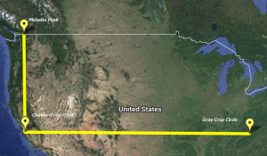
A crop circle to brighten up these winter days – what a sweet surprise!  The surprise was kicked up a notch when I added the Chualar, California formation to the all-in-one alignments map, where the circle corresponds notably to Pleiades Peak in Washington state and to the Gray, Tennessee crop circle of 2012:

Click here to access an interactive map of the above alignments.

Following the release of what appears to be a staged video of the formation’s discovery and reports of a group of people working in the field the day before, many have dismissed the circle as a run-of-the-mill hoax.   Just a few years ago I may have written it off as well – but after considering the human circlemakers who claim to be enigmatically inspired or compelled to create specific symbols in precise locations, I’ve changed my position.  After all, I’ve had numerous experiences of my own where I was seemingly guided to the right place at the right time for some “paranormal” event to occur, so why not others? The bottom line is that I can’t deny that human-made formations may be part of the communication from a non-human source – and I believe that’s what may have just happened in Chualar.

Regardless of how it was created on the ground, the details at Chualar confirm that it’s a part of a custom-designed mode of communication that I’ve been diagramming for the past couple of years: flat-map alignments as symbols used in non-verbal expression by an Other Intelligence. The design contains or alludes to both Braille and Morse Code, as well as other communication systems. Not only do the shape and details of the Chualar circle echo the idea of an actual encoded language, but the formation’s location on the map provides a new communication to be read through the alignments map: the addition of the Braille Number Sign to “read” (or decipher), just like the Braille Number Signs at Chualar show us how to read the numbers “192” that repeat within the circle’s inner rectangle.

The “L” shape jumps out once Chualar is added to the map – it’s on a north-south line with the Pleiades Peak and an east-west line with the Gray, Tennessee crop circle of last summer (and which hadn’t directly tied in with the alignments until now). These north-south and east-west correspondences resonate with an established motif in the all-in-one alignments map: Spanish Fork UT and Teton ID fall on the same longitude line; Langdon ND and Plevna KS are on the same longitude line, as is Langdon KS, where I graduated from high school; Pleiades Peak and Langdon ND appear on the same latitude line; Wilbur WA and Thompson ND are on another latitude line; Spanish Fork UT and Boulder CO fall on the same latitude line. I really like the way the Chualar circle pulls “Gray” into the conversation through one of these special grid alignments.
“192” has got a multitude of possible meanings, but I find it especially curious that 192 is the Dewey Decimal number for library materials on the Philosophy of the British Isles – quite possibly a reference to the St Michael ley connection via the Bermuda Triangle with the Pleiades Peak, a very expansive flat-map alignment which was detailed in my last post two weeks ago.  And researcher Glenn Aoys from the Netherlands has found a link from the number 192 to the colour gray in a completely different context than Gray, Tennessee, bringing extra emphasis to that connection.

One question that I’m still pondering: Was this a predictive or derivative alignment? In any case, connections and resonances between Chualar and the alignments map – too many to detail at this moment – continue to arise. What matters is that all of these point to the reality of a language which Bright Garlick recognised when he wrote, in response to my posting of the original triangle alignments map, “Something you have hinted at, that I also think might be true – is that whatever is creating these circles and larger scale patterns, is using geometry as a means to tell us ”I noticed you and have responded!”. Which I reckon is a pretty strong way to confirm something that otherwise seems very subjective and hard to prove. We seem to find the proof we need, when we know how to look and sometimes we seem to be guided to that as well.” Thank you, Bright; I couldn’t say it better myself.

Information continues to stream from the resonances brought forth with this new alignment and will be posted here as it is compiled and analysed.

IMPORTANT NOTE: If you are new to Flat-Map Alignments, please see FMAs: FAQs.

STACE TUSSEL COLLIGAN

See also The Layered Language of Crop Circles:  Connecting the Dots in Extraordinary Phenomena Research and subsequent posts on alignments published here.
Flat-Map Alignments: Bridging the Crop Circle Gap

Monday, December 16th, 2013

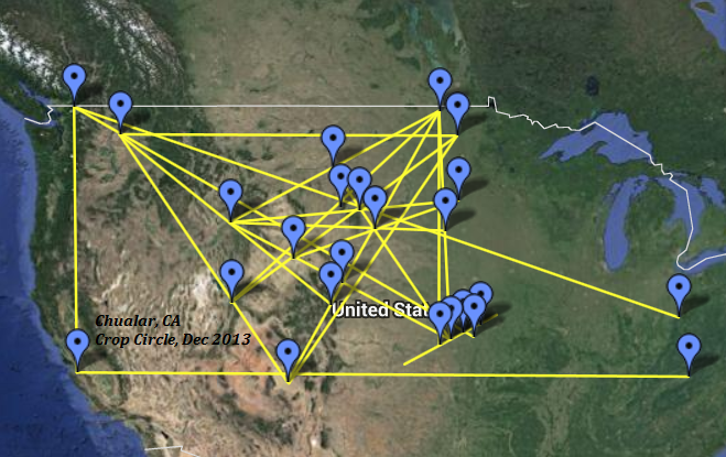
The following flat-map alignments communicate a connection between US and UK crop circles via the Pleiades, the Bermuda Triangle, and the St Michael ley which runs through crop circle country in southern England:

Explore an interactive version of this map – which stems directly from the original Triangle Alignments and associated maps linking Pleiades with the TIP line via the Wilbur 2012 circle and with the Hopewell Mounds 2012 circle via Bear Butte.

Please remember that these maps are in no way intended to reflect the spherical nature of Earth. The flat map is simply the surface on which messages from the Other Intelligence can be written, using a language comprised of symbols and ideas that are anchored on the planet and graphically depicted through geometry.

The TIP line that started all of this back on 16 June 1995 was relatively short, which when depicted on a spherical map is a nearly identical line.  For the three points in that first contact (Topeka, Inman, Plevna) to fall with almost mathematical precision on one line was, to me, no accident.  Millions and millions of square miles, as seen on this map, make even flat maps less user-friendly – which is why there is no “exactness” to this map.  The angles change subtly and sometimes not so subtly as you zoom in closer or zoom out.  Like crop circle synchronicities, these flat-map alignments are a way for the Other Intelligence to tap on our shoulders and say “take notice here.”  I find the resonance between the size, shape, and position of the original triangle alignments map and the Bermuda triangle noteworthy in this regard.

My father’s first cousin Bobby disappeared in the Bermuda Triangle in 1954, so I have a personal connection to that mysterious place.  Despite the smear campaign against it, as with crop circles, the Triangle really is a mystery.  Could it be a portal between dimensions or worlds – and could the Other Intelligence associated with the crop circles therefore be sending a message with this map that they are associated with the Pleiades and that they utilise the Bermuda Triangle as a portal to visit Earth?

IMPORTANT NOTE: If you are new to Flat-Map Alignments, please see FMAs: FAQs.

STACE TUSSEL COLLIGAN

Look Who’s Talking in Wilbur: The Other Intelligence Chimes In on Crop Circle Alignments

Sunday, October 7th, 2012

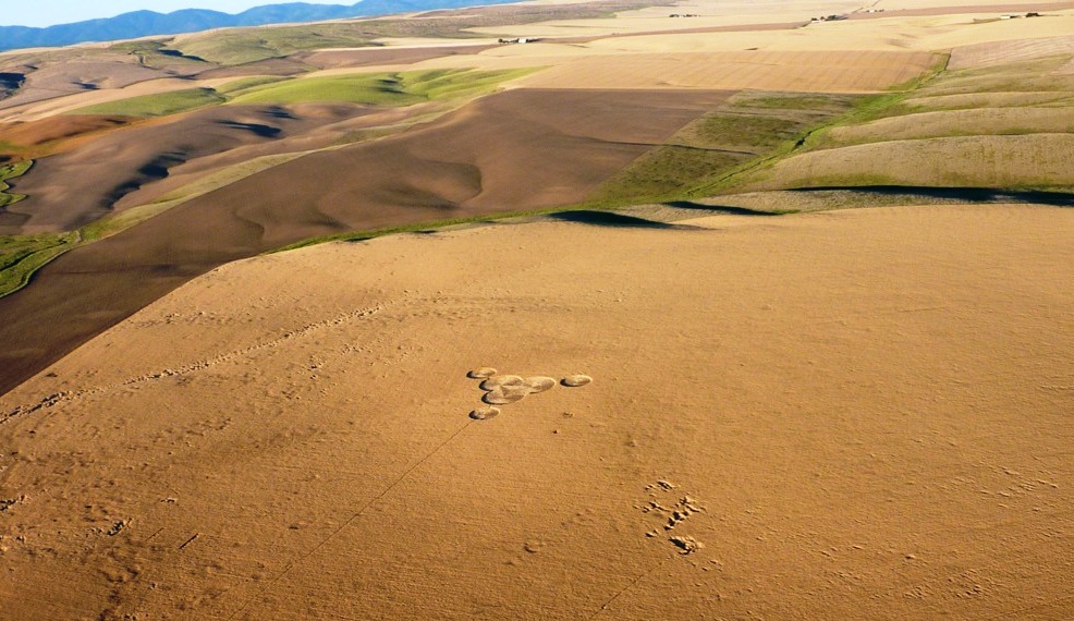
Photo courtesy of Larry Doty

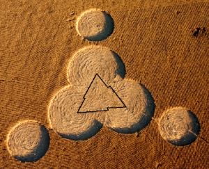
Wilbur 2012 as seen from ultralight aircraft. Photo courtesy of Larry Doty

Two crop circles have appeared in the United States since my alignments map was posted in July, and each independently reveals a connection to the Other Intelligence.  Both the Wilbur and Chillicothe circles, in fact, can even be read as deliberate replies to that map explication.  Indeed, what other form would such a reply take?

Speculation aside about exactly how the circle came to appear in the field, consider the evidence pointing to the involvement of the Other Intelligence in Wilbur’s design and geographic placement.  Through the interpretive keys of shape, synchronicity and alignment, what understanding might we derive from these new circles?  Are map alignments a litmus test for communication with the Other Intelligence?

Shape and Synchronicity “Where the Lightning Strikes”

Wilbur 2012 appeared almost like a comment written in wheat a few days after I published The Sum of Its Parts:  Finding Emergent Meaning in Crop Circle Maps. The diagram was immediately and intensely hypnotic; something about it drew me in completely.  I found the formation’s threefold geometry graceful and balanced, echoing the triangular alignments map.

Looking past the relatively-simple outer borders of the formation we see a dynamic inner triangle in the wheat, created by the floor pattern.  The triangle’s luminous zigzag border is comprised of three lightning bolts joined to form a triangle shining up from the circle’s floor.  For clarity, I’ve outlined it in the photo here.  What could it mean?

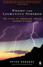
One book used in my research for the alignments map explication was Where the Lightning Strikes:  The Lives of American Indian Sacred Places, by Peter Nabokov.   Weeks earlier, the book had been central to a smallish synchronicity when I had first opened the it randomly to the page dedicated to Bear Butte.  The zigzag feature of the Wilbur 2012 crop circle seems to be saying, “Look!  Here is where the lightning strikes.”

And then there was the time lightning from a clear blue sky struck very near me in Kansas, in the utter absence of any storm – an event without mundane explanation.  I associate the errant lightning with the UFO sightings and apparent ET encounters involving electricity that I was experiencing fairly frequently at the time, contact which reached a peak with the arrival of crop circles in my life in 1995.

Might electricity itself be a clue from the Other Intelligence?   I just now looked online and found a brief 1985 article in The New York Times titled “Electricity May Play Role in Plant Growth.”  The article reports that researchers had shown that, depending on the direction of the current, plant growth was either accelerated or stunted by the application of electricity.  The premise that electricity can be applied to affect plant growth is demonstrated in my own living room, where a 4-foot tall hibiscus tree stands near the television, and the branches directly over the back of the TV set have leaves twice or three times the size of the other leaves.  I wonder if the Herington, Kansas crop circle, which showed a full range of accelerated and decelerated growth while in the field, may have carried information about the potential applications of the circlemaking energy, which may be electric in nature.  I haven’t yet explored possible alignment map correspondences with the Herington formation, but with this new insight in mind, another article may be in the offing.

A Path to the Pleiades Via Crop Circle Alignments

When we actively seek to interpret the messages carried by crop circles, we find that shape alone barely scratches the surface.  Synchronicities help refine the unique meaning we derive from a given formation, which may in turn assist us in deciphering universal messages as well.  Map placement, especially with a predictive quality, has been offered as a possible indicator of the Other Intelligence, since many of the alignments I’ve found thus far suggest an omniscient presence working behind the scenes.  So naturally, the next step in deciphering Wilbur 2012 involves plugging it in to the existing alignments map.

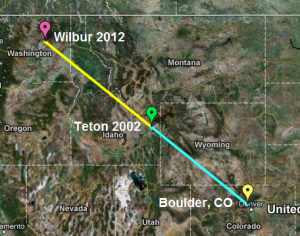
As I anticipated, Wilbur created a new and especially pertinent alignment:  The 860-mile long direct line between myself and the Wilbur circle is lengthened by only two miles if we factor in a slight detour to the Teton circle.

Once this line was established, I noticed that if extended beyond Wilbur, the line continued on through the mountainous region of northern Washington.  Wouldn’t it take the cake if it led directly to the Pleiades Mountain summit in the North Cascades?  I was disappointed when I found the line didn’t match up, but I was compelled, nonentheless, to see if Pleiades summit showed up via any other alignments on the map.  The importance of the Pleiades star system to the creation stories of the Lakota and other cultures can’t be overstated, and I’ve shared in great detail how the Pleiades infused my crop circle initiation in 1995.  Because of these correspondences, I felt absolutely certain that Pleiades summit would play some role here, so I dug deeper.

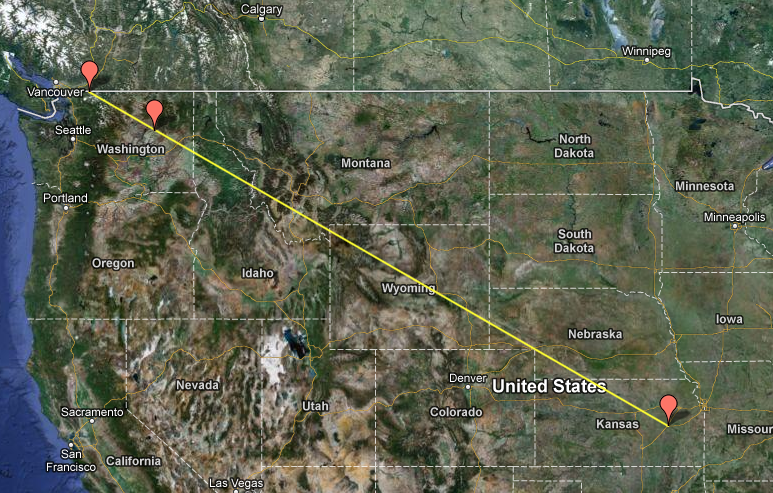
Where to look next?  In 1995, when all the Pleiadean connections came flooding to me in the weeks just prior to the Inman crop circle, I was living in Emporia, Kansas.  That had to be it!  I placed my home near 15th and West Street in Emporia on the map, extended a line from there directly to the Pleiades summit 1458 miles away, and voila!  The line breezes past Wilbur 2012.  My understanding of this?  The crop circles, the Other Intelligence and the Pleiades are all interconnected – and by virtue of our participation we realise we are an integral part of the web of connection too.

With the addition of Wilbur and the Pleiades summit to the alignments map, it seems there is no end to the correspondences that continue to arise by intuitively exploring the encoded information.  The next installment of map additions and explications is coming soon, with additional power spots and several latitude/longitude synchronicities added.  Next we’ll see what happens when we factor in the location of the Hopewell Mounds crop circle near Chillicothe, Ohio.

IMPORTANT NOTE: If you are new to Flat-Map Alignments, please see FMAs: FAQs.

STACE TUSSEL COLLIGAN

Click to explore Interactive Maps!
View Crop Circle Alignments (Original Map) in an Interactive Map
View Boulder-Teton-Wilbur Line in an Interactive Map
View Emporia to Pleiades Direct in an Interactive Map
View All-in-One Crop Circle Alignments Map in an Interactive Map (overview of the current established alignments I’m in the process of explicating)

The Layered Language of Crop Circles: Connecting the Dots in Extraordinary Phenomena Research

Sunday, October 16th, 2011

Please access the interactive maps via links accompanying the photos, as they will allow you to explore the alignments discussed here.

Map created with help from Mike Clelland.  Visit Mike’s site Hidden Experience for more insights into synchronicity, ET contacts, and other curious topics.

Crop circles, UFOs, and synchronicities are clues to our connection with a largely-unseen web of reality.  Our interactions with these phenomena demonstrate that we aren’t isolated packets of consciousness, but that we are transmitters and receivers of meaning through language.

We find that where these extraordinary phenomena occur in conjunction with one another and are then plotted on a map, a brilliant and always-evolving syntax emerges.  As we wish, we are given to explore a language that has nothing to do with the describing the mundane and everything to do with navigating the fringes of reality.

In this first of two posts, I’ll lay the framework for an upcoming report detailing my ongoing exploration of what these alignments may mean.  Of course, like all the great mysteries of life, our understanding of this elusive level of reality is ultimately subjective, so I invite you to draw your own conclusions.

ONE: The Topeka-Inman Line.  This straight alignment in Kansas is comprised of three interrelated locations: 1) the place where I privately wished for a crop circle, 2) the place where I learned about the requested crop circle five days later, and 3) the location of the crop circle itself.  This discovery confirmed the extraordinary nature of my crop circle initiation in 1995.  View Stace Tussel – Inman Crop Circle Alignment in a larger map

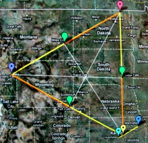
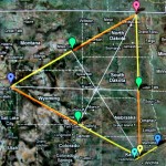
TWO: The Triangle. Plotting the locations of three key crop circle locations in my research of US formations from 1995 through 2002 creates a near-equilateral triangle enclosing 246,792 square miles, referencing Kansas at 82,282 square miles, tripled, which equals 246,846 square miles – a difference of just 54 square miles, which is roughly the size of the overlapped triangle in the middle of the large one (apparently an artefact of the mapping process, possibly having a connection to satellite techniques and Earth curvature, since the centre of a triangle should be a point, and not another triangle).  View Stace Tussel – Crop Circle Alignments in a larger map

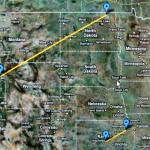
THREE: Parallel Lines.  The overlay of maps one and two elicited another alignment speaking to the connectedness of all the phenomena.  From a direct E-W (equatorial) line, the Inman formation appeared at an angle of 29 degrees, and the line between Langdon and Teton runs on the same parallel angle of 29 degrees.  View Stace Tussel – Parallel Lines in a larger map

STACE TUSSEL COLLIGAN

NOTE:  As mentioned, the potential significance of these alignments will be explored in more detail in an upcoming post.